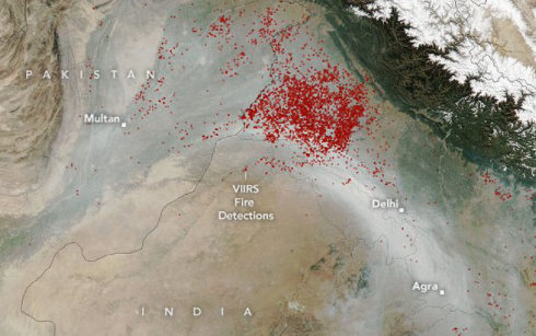
Nov. 20 – India’s air pollution has continued to deteriorate in recent days. After winter, the capital of India, New Delhi, and its surrounding areas are even more “poisonous fogs”. According to a report on India’s Wiionews website on the 19th, satellite images released by NASA show that the sky over New Delhi, the capital of India, is full of red spots and pollution levels have reached dangerous levels.
NASA posted on social platforms on the 18th that smoke from burning straw in northern India enveloped New Delhi, causing air pollution to soar. According to the report, the satellite image date is November 11, and the satellite detected a large amount of smoke in northwest India. Pawan Gupta, a scientist at NASA Marshall Space Flight Center University Space Research Association, said, “From the scale of smoke on November 11 and the population density of the region, it is conservatively estimated that at least 2200 million people in India were affected by smoke pollution on that day.”
According to the report, the Indian capital has always been rated as the worst air quality in the world. Delhi has been dealing with air pollution since the beginning of November this year. Last week, Delhi’s PM2.5 index seriously exceeded the standard, exceeding the average daily safety ceiling recommended by the World Health Organization (WHO). The government of the capital New Delhi has announced that all local schools will be closed indefinitely from the 17th until further notice. More than half of the local coal-fired power plants will be closed from the 18th, hoping to improve the air pollution problem in New Delhi.